New Montecito Risk Map affects almost 1,000 properties; flash floods still a concern
MONTECTIO, Calif. - County officials unveiled an updated debris flow risk map for the Thomas Fire burn scar in Montecito at a town hall meeting Thursday.
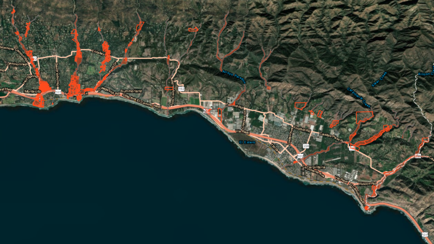
The map indicates a change in status for close to one thousand properties but that doesn't necessarily mean they should let their guard down.
If you compare last year's map to this year's you'll notice a lot less red and officials say 85% of that is a healthy dose of vegetation regrowth.
The new Montecito Debris Flow Risk Map shows 517 parcels that are of concern, whereas last year close to 1500 were in the red.
“The reason for that is because the watershed is a little over 80% recovered, ring nets have been added, the debris basins are empty and the creek channels are clear,” said Kevin Taylor, Montecito Fire Protection District Chief.
Curtis Skene is still in the red but he’s relieved the schools are safe.
“I think it’s really important to understand how we can protect ourselves we all as individuals need to be proactive,” said Skene, a two-time survivor.
For the RenewSB Executive Director, it’s a powerful case of deja vu.
“I was in my house on 1-9 and I shouldn’t have been. If I was paying more attention, I wouldn’t have been there,” said Skene. “I saw the 1969 event, that was very much more a debris-laden flood, it was more of a flood so tonight when they talked about the fact that the risk is more of a flood than a debris flow I know that’s right,” he adds.
The area is still at risk for a debris flow three to five years after the fire and officials say year three brings flash flooding concerns.
“It’s not going to have the same impact as it had before where the water droplets hit the ground and started to move material. It’s more about it’s going to shed water faster and cause more flow in the rivers and the creeks and flooding,” said Eric Boldt, National Weather Service Warning Coordination Meteorologist.
While the maps are designed for emergency management purposes, County Supervisor Das Williams spoke to the California Insurance Commissioner on Thursday.
“Our understanding is that this will help, it will help create some pressure on the insurance companies to not issue non-renewals and so we are hoping and asking the insurance commissioner to add the Thomas Fire burn area onto the moratorium,” said Williams. Williams says Commissioner Ricardo Lara told him he’s waiting on some key information from Cal Fire.
For residents like Sken, the situation is different than it was two years ago but in a positive way.
“When I walk out of this meeting tonight I feel good,” said Skene.
County officials also want to clarify that the newly released map is specifically for Montecito. Experts are actively working and collecting data for a Cave Fire debris flow risk map but since that fire hasn’t reached full containment, information is still being assessed.
