Transporter-11 mission delivers new type of satellites developed by Santa Barbara company

VANDENBERG SPACE FORCE BASE, Calif. – One of the payloads aboard the Transporter-11 Mission, the latest Falcon 9 launch on Aug. 16, was Umbra's pair of new Synthetic Aperture Radar satellites.
The recently launched pair joins Umbra's existing group of orbiting satellites, eight in total, and plans are in the works to expand to a full 32-satellite constellation detailed the Santa Barbara-based company in a press release about the new satellites.

Synthetic Aperture Radar (SAR) systems remotely gather a sequence of source material to create a more detailed image.
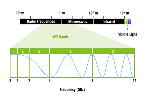
The image below shows the electromagnetic spectrum with microwave bands shown in more detail.

We can only see a small part of the electromagnetic spectrum with the unaided eye (shown as the rainbow part on the far right of the bar) and these satellites generate images based on wavelengths we can't see.
So what exactly is synthetic about these satellites?
What is synthetic is the way these satellites collect data.
Spatial resolution of radar data is directly related to 1.) the ratio of the sensor wavelength and 2.) the length of the sensor's antenna explained the National Aeronautics and Space Administration (NASA) on their webpage about SAR platforms.
As a workaround of needing larger and larger antennas to improve image resolution, scientists and engineers developed a way to simulate a large antenna using a series of data collections from smaller antennas and combining them detailed NASA.
In other words, while real information is being collected, SAR satellites work together to generate images that would otherwise require a much larger antenna. They create a synthetic aperture, a tool used to limit light captured by a device that you might find in a camera, to generate an image of the subject.
Umbra has multiple contracts with government and commercial organizations, including Maxar Technologies, the largest commercial satellite imagery vendor in the United States, and an example is shown below of how SAR scans can be paired with existing satellite systems.

"Umbra already delivers the largest volume of high-resolution SAR imagery in the concentrated
areas of highest demand," said Todd Master, Chief Operating Officer of Umbra. "These
additional satellites will unlock even more imagery over high-demand areas for our customers,
and our paired operations offer the ability to generate incredible data products uniquely enabled
by Umbra."
For more information about imaging modes using Umbra's SAR satellites, visit here.
