Parts of Santa Maria identified as a wildfire hazard area for the first time ever
SANTA MARIA, Calif. - For the first time ever, California fire officials have identified the City of Santa Maria as a wildfire hazard area.
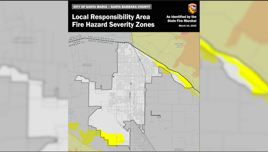
New hazard maps recently released by the California Department of Forestry and Fire Protection (CAL FIRE) show parts of Santa Maria with a designation of having a "moderate" risk for a wildfire.
"Up to this point, before this new map, Santa Maria did not have any designated high fire zones within our city limits," said Santa Maria Fire Marshal Jim Austin. "Now we have an area, a small area identified in the northeast area of town, next to the Santa Maria Riverbed, and we have another area, in the southwest, identified near the, Pioneer Park and the airport in that area."
The CAL FIRE maps were updated for the first time in 14 years and rank fire likelihood in certain areas from Moderate, High, or Very High.
"It's based on new technology and scientific analysis, including what they call, ember intrusion," said Austin. "That updated a lot of areas, approximately 200 cities have received a new designation as having a high fire zone within their jurisdiction where previously they did not."
The three wildfire fire designations are based on consistent statewide criteria, including fuel loading, slope, fire weather, and other contributing factor such as wind patterns, that may influence the likelihood and behavior of wildfire.
No parts of Santa Maria were given a designation of High or Very High.
"What it means for Santa Maria and the residents, we don't see any additional impacts," said Austin. "Those areas are built out for the most part and we have response protocols that we've been used them for decades out there that still work. Nothing has changed physically for us other than this identification, and so you won't see any changes from, a building construction standpoint or a vegetation management standpoint because it's been that way prior to this designation."
According to Santa Maria, the city's draft map was first published on March 10th and is now available for public review and comment.
In accordance with State law, the Santa Maria City Council must adopt and designate updated zones by ordinance within 120 days of receipt.
"We received our letter (from CAL FIRE) on March 10th," said Austin. "We have since disclosed and put it out on our website and our social media outlets and things like that, so we have let the public know. The other requirement from the state is to have a, an ordinance adopted within 120 days of receiving the letter that we recognized and accept the designation from the state. Santa Maria City Fire is in process of doing that right now. The draft ordinance has been written. We hope to get on the agenda for April 18th. If not, it'll be the next agenda two weeks from then, so we will meet that deadline."
