Helene forecast to rapidly intensify and hit Florida as a major hurricane
By Mary Gilbert, CNN Meteorologist
(CNN) — An area of thunderstorms in the Caribbean is expected to develop into Hurricane Helene and rapidly intensify over the exceptionally warm Gulf of Mexico before slamming into the United States’ Gulf Coast later this week as a major hurricane.
The storm has not formed yet but is expected to soon, so the National Hurricane Center has dubbed it Potential Tropical Cyclone Nine to warn of its imminent threat.
“Strengthening is expected during the next few days, and the system is forecast to become a hurricane on Wednesday and continue strengthening on Thursday as it moves across the eastern Gulf of Mexico,” the hurricane center’s 8 p.m. advisory said.
The system has a 90% chance of forming into a hurricane in the next 48 hours, according to the center.
Hurricane and tropical storm watches are in effect for parts of Mexico and Cuba. A tropical storm watch was raised Monday afternoon for Florida’s Dry Tortugas and part of the Keys. Additional alerts will be issued for the US in the coming days, with a potential landfall in Florida expected perhaps as soon Thursday evening.
Florida wasted no time getting preparations underway. Gov. Ron DeSantis declared a state of emergency ahead of the storm for 41 the state’s 67 counties, according to a Monday press release. The move helps to expedite preparations and coordination between the state and local governments.
Potential Tropical Cyclone Nine is a disorganized mass of showers and thunderstorms churning in the far western Caribbean Sea. This stormy weather will drop potentially flooding rainfall over portions of Central America, Mexico, Cuba and Jamaica as it tries to organize into a tropical system.
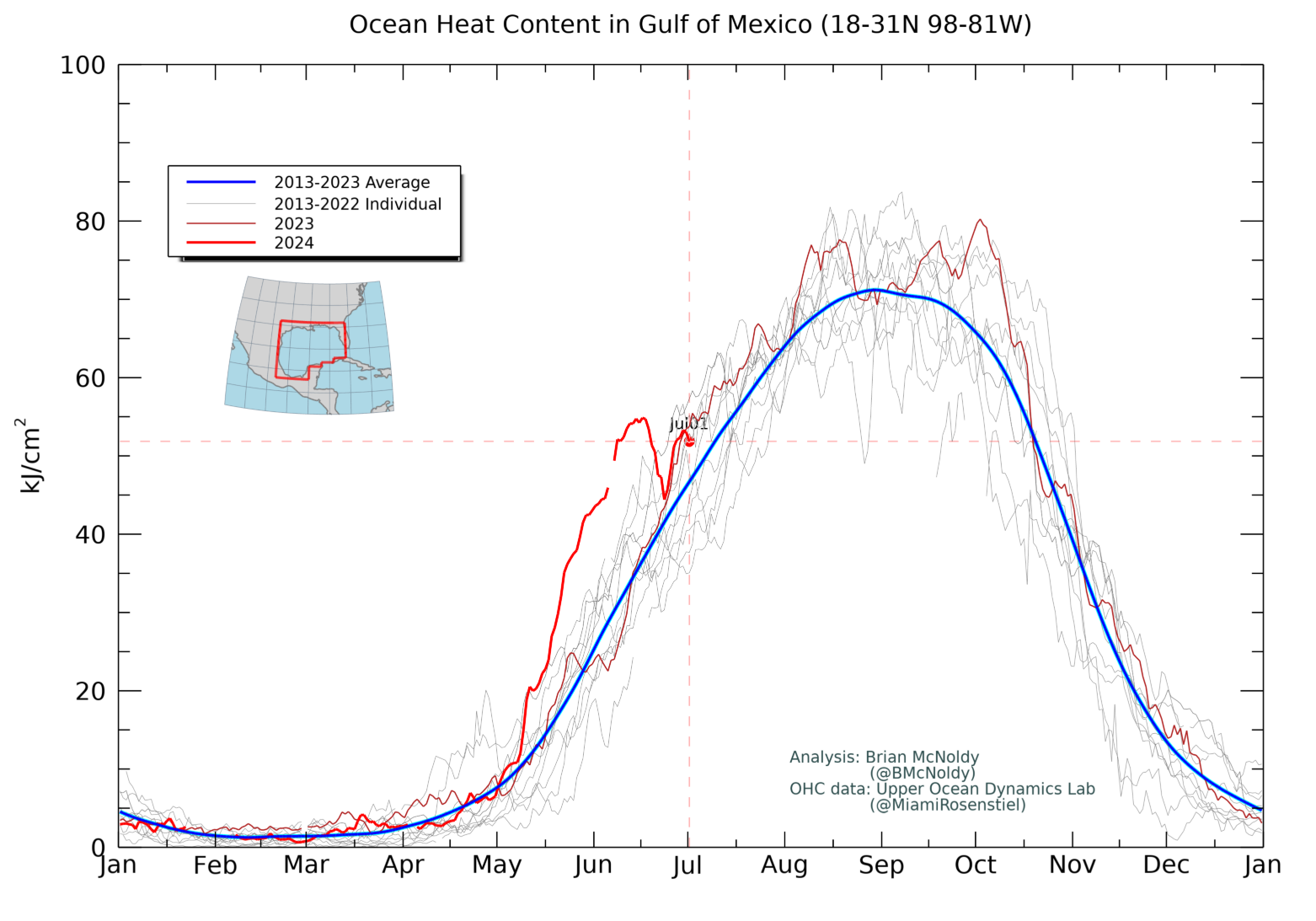
While its exact track and strength could change, Helene will track north over the extremely warm waters into the Gulf of Mexico which will likely supercharge it on its collision course with the US Gulf Coast.
The National Hurricane Center is forecasting Helene to rapidly intensify and eventually become a Category 3 hurricane over a record-warm Gulf of Mexico – a feat becoming more likely as the world warms due to fossil fuel pollution.
Strong, potentially damaging winds and storm surge are likely near where the system ultimately comes ashore. The system will also churn up seas in the Gulf and could produce rough surf and dangerous rip currents for much of the basin, especially later this week.
The National Hurricane Center is showing a landfall in Florida’s Big Bend region, but anyone from Florida’s Gulf Coast to eastern Louisiana should be on alert this week.
Confidence in the system’s exact track will increase after it forms, since forecast models struggle to accurately pinpoint where it could go without a center to lock onto.
Ensemble forecast models – groupings of many model runs initiated with slight differences to show a wide range of outcomes – are focusing on the eastern Gulf Coast as the area most likely for a landfall later this week. When ensemble tracks bunch closer together it means there’s more confidence in the track.
There’s a closer grouping with this storm along the eastern Gulf Coast, but given it hasn’t formed yet it’s not a guarantee.
Tampa General Hospital began erecting a 10-foot-high flood barrier around the facility Monday because of the chance for storm surge and shifts in the storm’s track with little time to prepare. The level one trauma center’s location next to Hillsborough Bay makes it extremely storm surge prone.
It takes three days for a 60 person team to fully erect the barrier to encase the hospital and work will continue “unless we see a forecast favorable enough to stop,” Dustin Pasteur, the vice president of facilities and construction at the hospital said. “I just couldn’t afford to lose a day waiting.”
Regardless of its exact track, heavy rainfall is possible for much of the Southeast starting around midweek. A level 2 of 4 risk of flooding rain is in place for much of Florida, Georgia, Alabama and parts of the Carolinas Thursday, according to the Weather Prediction Center.
The system’s danger won’t end after landfall either. Helene could bring strong winds and torrential rainfall to much of Georgia and the Carolinas by Friday. This could lead to dangerous flooding and significant power outages.
Another impactful storm for the US and Florida
Helene is forecast to become the fourth hurricane to make landfall in the US this year. The three others all rapidly intensified before striking the US as hurricanes: Beryl, Debby and Francine.
The last time four or more hurricanes hit the US in one season was the devastating 2020 season.
Despite the rash of impactful storms, if Helene manages to landfall as a Category 3 it would be the first major hurricane to do so in the US since Idalia slammed into Florida’s Big Bend last August.
Helene would continue a brutal stretch for the Sunshine State. Helene is forecast to be the fifth hurricane to slam Florida since 2022. The repeated blows have pushed the insurance market in the state to the brink, with insurers pulling out of the state because of the increasing risk of extreme weather due to climate change.
CNN’s Isabel Rosales contributed to this report.
The-CNN-Wire
™ & © 2024 Cable News Network, Inc., a Warner Bros. Discovery Company. All rights reserved.