Santa Barbara city sea level rise vulnerability assessment to be released in February
SANTA BARBARA, Calif.
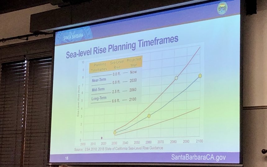
Sea level rise or SLR is a hot topic in coastal communities, including Santa Barbara.
At the newly formed council's first meeting of 2020, project planner Melissa Hetrick gave a sea level rise presentation.
Council members listened to a vulnerability assessment created by Environmental Science Associates.
The consulting firm looked at sea level rise between .08 and 6.6 feet between the years 2030 and 2020.
"The portions of city will be different in the way they might be impacted the bluffs areas will be impacted differently than the low lying waterfront areas and will experience more beach loss, in the beaches that are backed by bluffs as opposed to low lying waterfront areas where we have more sand and room to move back," said Hetrick"
She said the public will be able to read the study late next month.
"We are releasing a plan in February called a Sea Level Rise Adaptation Plan and we will recommend actions to mitigate the impact and this is just the beginning of the process."
Council members said they are not going to debate the issue, they are going to take action this summer.
For more information visit SantaBarbaraCA.GOV/SLR.
