New evacuation warning map posted ahead of coming Santa Barbara County storm
Santa Barbara, Calif -- Santa Barbara County posted a new evacuation map Tuesday night. It was posted on ReadySBC.org
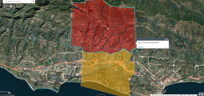
The map shows Santa Barbara residents between Patterson Ave./Anderson Lane in Goleta to the west and Ontare Rd. between the 3500 and 3300 block of State Street and down through Las Positas Road, and south of East Camino Cielo to the ocean are in the evacuation warning area and should be ready to leave.
In the City of Goleta, the Debris Flow Evacuation Warning Area includes the area close to Maria Ygnacio Creek and Patterson Avenue, south of Highway 101.
The map was issued ahead of anticipated storms. Public safety officials have determined that there is a risk for potential debris flows in and below the Cave Fire burn area, according to the county.
The Santa Barbara Office of Emergency Services said residents can call the Emergency Call Center: (833) 688-5551 for more information on the Evacuation Warning.
The Santa Barbara County Sheriff's Office also announced Tuesday night that the evacuation warning was lifted for the area north of Foothill Road between Ontare and Gibraltar Road.
The mandatory evacuation area remains the same. It includes areas above Foothill Rd. and Cathedral Oaks Rd. between Ontare Rd to the east and Patterson to the west.
Officials said if a debris flow occurs, and it is unsafe to leave, or you are unable to leave, go to high ground. Stay alert to changing conditions and follow the instructions of public safety officials
If you live or are near creeks and streams, be aware that waterways may experience high flows and can rise quickly. Flooding impacts may be experienced throughout the county, but are a higher risk and may be observed below the Thomas, Sherpa, Alamo and Whittier burn areas.
The Ready SBC website includes an interactive map. Residents can put in their address to see if they are in an evacuation area.
People as far north as Buellton and Santa Maria reported getting the emergency alert only in Spanish.
The City of Santa Barbara Office of Emergency Services responded to questions about the alert.
The agency tweeted, "We understand there were issues with the emergency alerts that were sent by our partners at the County Office of Emergency Management. We’re also aware of people who had different wireless providers received both English & Spanish alerts."
We reached out to the Santa Barbara County Office of Emergency Management for a comment about the alert and to get an update on the evacuation warning. We are waiting to hear back.
