Flooding temporarily closes major Bay Area highway and prompts evacuation warnings in northern California neighborhoods
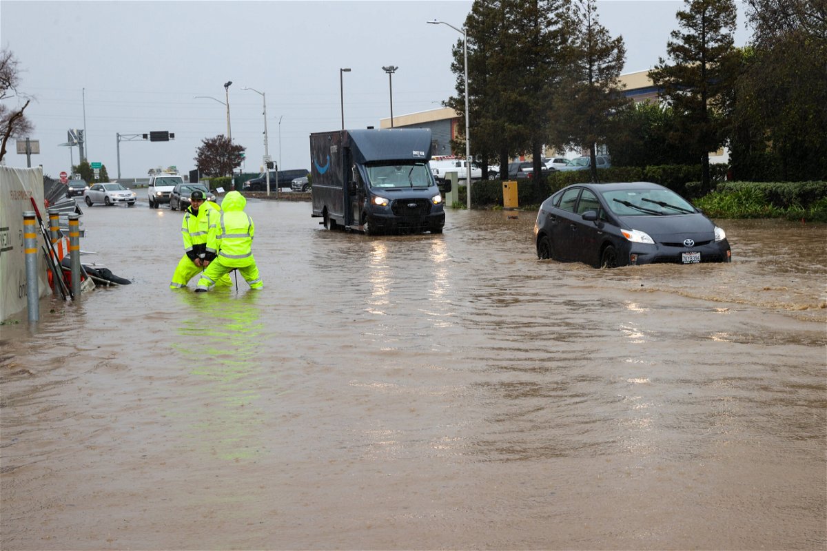
A rainstorm causes flash flooding in San Carlos
By Andy Rose and Alaa Elassar, CNN
Heavy precipitation and snow melt flooded roads and led to freeway closures and evacuation warnings in Northern California on Saturday, officials said.
At one point, US Highway 101 — one of California’s most famous routes — was closed in both directions in South San Francisco as “water is not receding due to non-stop rainfall & high tides preventing the water to displace,” California Highway Patrol said in an evening update. The freeway reopened later Saturday evening after flood waters receded, CHP said.
Authorities were also working to rescue submerged vehicles from the highway after some had chosen to drive through the closures, the agency said.
The California Department of Transportation also advised of a partial closure of Interstate 80 near the Nevada line midday Saturday “due to multiple spinouts over Donner Summit.” Driving through the mountain pass in the Sierra Nevada range has required tire chains for much of this month due to heavy snowfall.
In Sacramento County and adjacent areas, residents were advised to avoid travel as wind gusts of up to 55 mph toppled trees and covered roads with debris, according to a tweet from the National Weather Service in Sacramento.
A strong storm that brought widespread heavy rain Friday through Saturday, creating a flood threat for much of Northern and Central California, is nearing unprecedented levels.
By Saturday evening, San Francisco was closing in on breaking the city’s record for single wettest day ever.
“Downtown San Francisco is now at 5.45 inches, just 9 hundredths of an inch away from the daily (midnight to midnight) record of 5.54 inches,” the National Weather Service said in a 5 p.m. update on Twitter.
And meanwhile, an active jet stream pattern also brought a parade of storms fueled by an atmospheric river of Pacific moisture.
An atmospheric river is a long, narrow region in the atmosphere which can transport moisture thousands of miles, like a fire hose in the sky. This heavy rainfall will slide southward to Southern California on Saturday and Sunday, accompanied by gusty winds of 30 to 50 mph.
Residents told to shelter in place
Several small communities in northern California were under evacuation orders and warnings Saturday due to flooding. Three communities near the city of Watsonville were told to evacuate by the Santa Cruz County Sheriff’s Office due to creek flooding, while officials ordered the communities of Paradise Park and Felton to evacuate due to rising levels of the San Lorenzo River.
Neighborhoods near the Santa Rita Creek in Monterey County were put under a warning Saturday afternoon because of concerns the creek “will spill over its banks,” according to the sheriff’s office.
Evacuations from the floodwaters were being conducted Saturday with the help of an armored rescue vehicle in south San Ramon.
Residents in the community of Wilton, roughly 20 miles from Sacramento, were ordered to shelter in place due to the rains and floods.
“Rising water has made roads impassable in the area,” Sacramento County officials said on Facebook, urging those who were already on the road to head to safety and those who were home to “stay at home.”
The county on Saturday issued a proclamation of local state of emergency for the winter storms, saying the atmospheric river it’s been experiencing has caused “significant transportation impacts, rising creek and river levels and flooding” in the Wilton area.
A flood watch for more than 16 million is in effect including the entire Bay Area and Central Valley though Saturday night. Rain could ease Saturday evening before the calendar turns to 2023.
Potentially historic rainfall
Earlier weather predictions said widespread rainfall accumulations of 2 to 4 inches are expected in northern and central California, but locally higher amounts of 5 to 7 inches are also possible for the foothills.
Northern California and the central California coast have already received 2 to 4 inches of rain in the last week. The cumulative effect of multiple Pacific storm systems laden with moisture from a potent atmospheric river will make impacts such as flash floods and landslides more likely.
Videos and photos shared by the National Weather Service in San Francisco show fallen trees blocking roadways, and multiple landslides.
In Oakland, local officials urged people to stay off the roads due to the heavy rain and flooding.
“If you have to travel, use caution. City crews are working through a backlog of reports of flooding and other weather impacts,” the city posted on Twitter.
The-CNN-Wire
™ & © 2023 Cable News Network, Inc., a Warner Bros. Discovery Company. All rights reserved.
CNN’s Dave Alsup contributed to this report.